Warning · alarm · scenario · exercise

The warning arrived.
Did preparation start?

The aim is not more notifications. It is a traceable preparation flow that reaches the right owner. Delivery, acknowledgement, task and close stay separate.

Official warning

Official warnings

Current authoritative records load from the official-warning adapters. This section is never an ECMWF chart.

Forecast context

ECMWF outlook charts — not an official warning.

These are ECMWF forecast graphics. They sit below official warnings. They are not MetOry risk, not MetOry alerts, and not the official-warning lane.

Winter

Rainfall outlook

Rainfall probability · Europe · next 24 hours

LAST KNOWN GOOD

Last known good ECMWF forecast chart · source product, not a MetOry official warning.
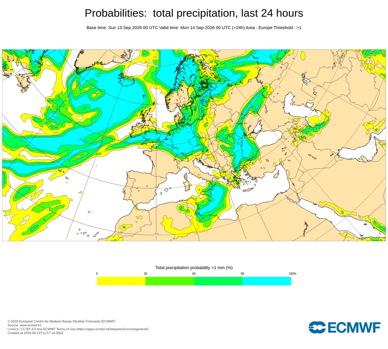
ECMWF Open Charts: Probabilities: total precipitation, last 24 hours. Europe. Base 13 Sep 2026 00 UTC. Valid 14 Sep 2026 00 UTC.

Shows where ensemble members indicate a greater likelihood of measurable rainfall during the selected period.
Where: Europe

Base: 13 Sep 2026 00 UTC

Valid: 14 Sep 2026 00 UTC · T+24

Source: ECMWF ENS · ECMWF Open Charts · CC BY 4.0

Product: Probabilities: total precipitation, last 24 hours

© European Centre for Medium-Range Weather Forecasts (ECMWF)

ECMWF ENS probability on this chart is ECMWF’s product. It is not MetOry confidence, MetOry probability, or MetOry risk %.

Strong wind outlook

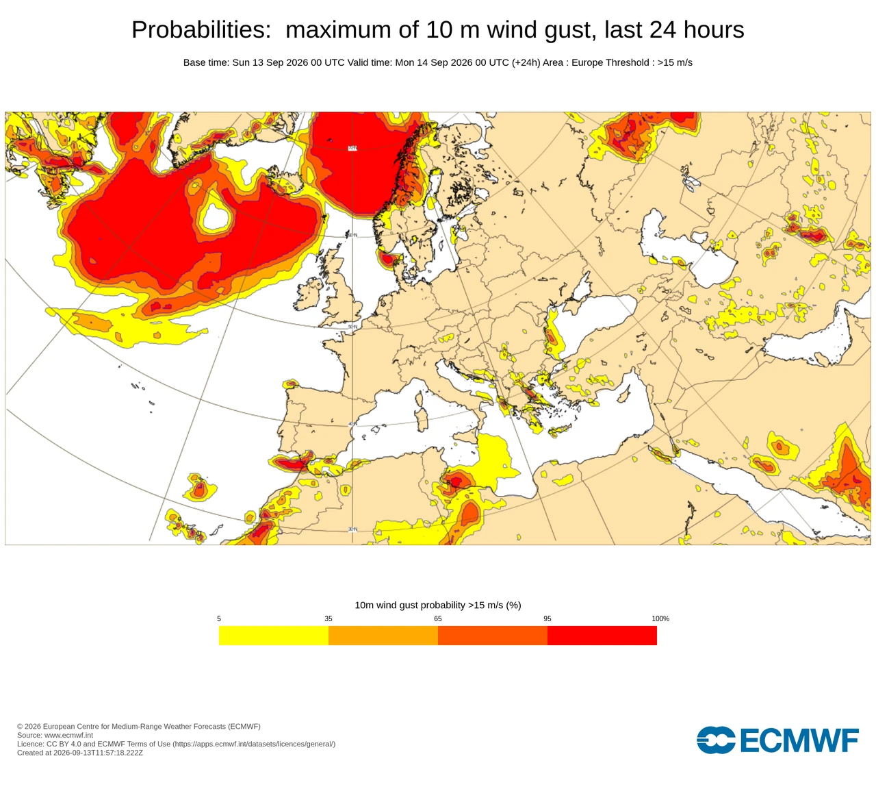
Maximum 10 m wind-gust probability · Europe · next 24 hours

LAST KNOWN GOOD

Last known good ECMWF forecast chart · source product, not a MetOry official warning.

ECMWF Open Charts: Probabilities: maximum of 10 m wind gust, last 24 hours. Europe. Base 13 Sep 2026 00 UTC. Valid 14 Sep 2026 00 UTC.

Areas where ECMWF ensemble forecasts indicate increased probability of strong wind gusts.

Where: Europe

Base: 13 Sep 2026 00 UTC

Valid: 14 Sep 2026 00 UTC · T+24

Source: ECMWF ENS · ECMWF Open Charts · CC BY 4.0

Product: Probabilities: maximum of 10 m wind gust, last 24 hours

© European Centre for Medium-Range Weather Forecasts (ECMWF)

ECMWF ENS probability on this chart is ECMWF’s product. It is not MetOry confidence, MetOry probability, or MetOry risk %.

Wind + rain outlook

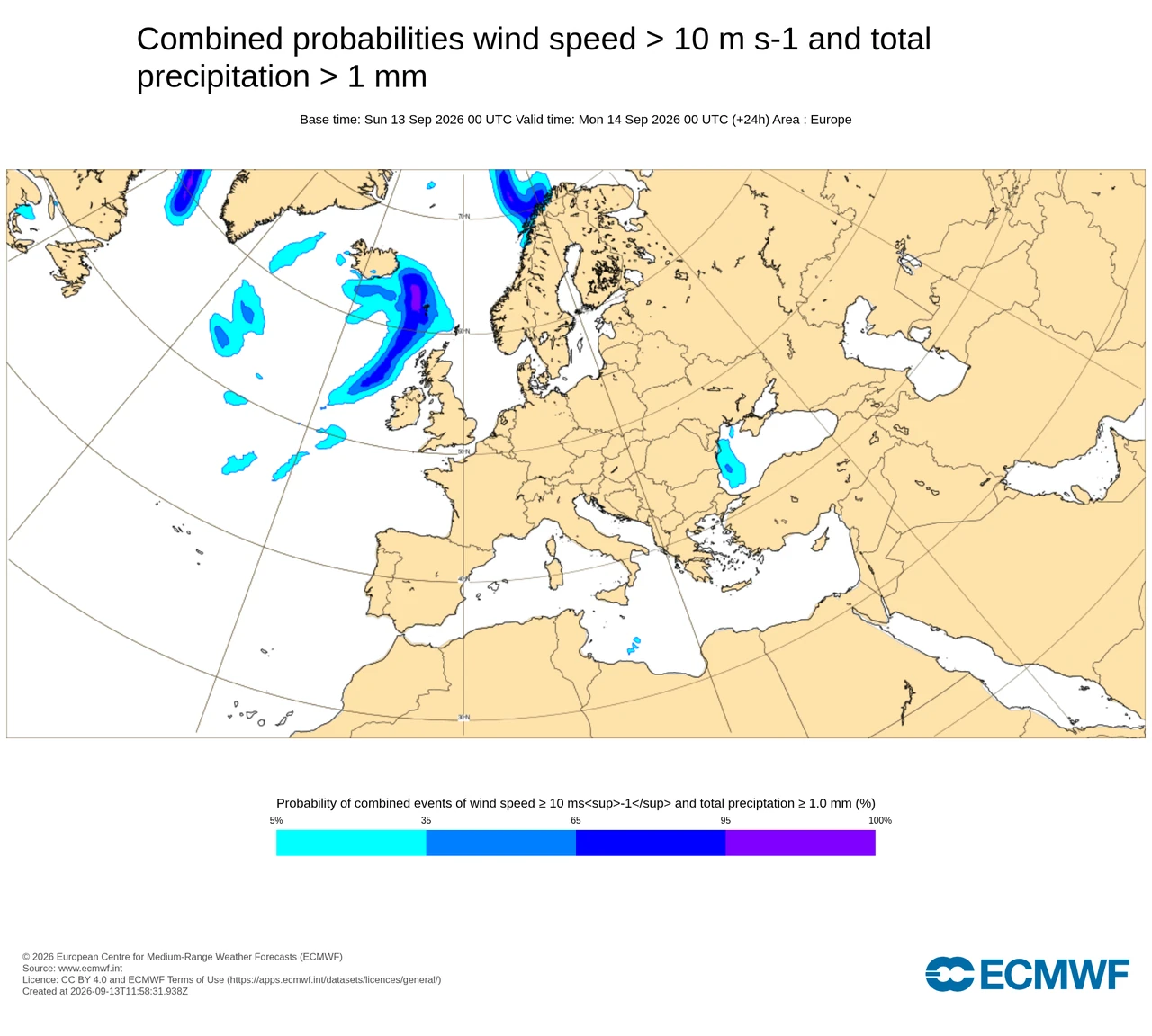
Strong wind and measurable precipitation together · Europe · next 24 hours

LAST KNOWN GOOD

Last known good ECMWF forecast chart · source product, not a MetOry official warning.

ECMWF Open Charts: Combined probabilities wind speed > 10 m/s and total precipitation > 1 mm. Europe. Base 13 Sep 2026 00 UTC. Valid 14 Sep 2026 00 UTC.

Areas where strong wind and measurable precipitation are forecast together. ECMWF combined probability is not MetOry operational risk.

Where: Europe

Base: 13 Sep 2026 00 UTC

Valid: 14 Sep 2026 00 UTC · T+24

Source: ECMWF ENS · ECMWF Open Charts · CC BY 4.0

Product: Combined probabilities wind speed > 10 m/s and total precipitation > 1 mm

© European Centre for Medium-Range Weather Forecasts (ECMWF)

ECMWF ENS probability on this chart is ECMWF’s product. It is not MetOry confidence, MetOry probability, or MetOry risk %.

Official warnings remain a separate authoritative feed. PARALLEL_NOT_MERGED.

Rete delle fonti

Meteorological source network

Global forecasting, Earth-observation and national meteorological authorities that support MetOry's weather evidence layer.

Fonti globali in evidenza

Fonti globali secondarie

Servizi meteorologici nazionali

National authorities add local observation networks, regional numerical forecasting expertise and, where connected, authoritative official weather warnings.

Vedi la rete delle fonti completa →

Source attribution does not imply endorsement of MetOry.

Lightning over a remote island during a storm.
Photo: Johannes Plenio / Pexels
Heavy ocean waves under weather-bearing sky.
Photo: Emiliano Arano / Pexels
Snow-covered trees in winter weather.
Photo: Eva Bronzini / Pexels
Sunlit sand dunes under a clear heat-bearing sky.
Photo: Francesco Ungaro / Pexels

Photographs are contextual. They are not incident records, not official warnings, and not evidence of harm.

01

Warning

See the relevant condition or official information. Keep source and validity.

02

Alarm

Reach the relevant people when an approved policy creates a workflow priority.

03

Scenario

Review options, uncertainty, residual impact and assumptions together.

04

Exercise

Rehearse acknowledgement and task flow in a separate test environment.

MV0–MV4

Work priority.
Not an official warning colour.

Impact is assessed together with remaining time to prepare. Real thresholds come from an approved activity policy.

MV0

Information

Relevant information; no defined task.

MV1

Monitor

Signal / uncertainty and re-examination.

MV2

Prepare

Approved preparation condition and owner.

MV3

High

Material impact, time pressure or confirmation gap.

MV4

Critical

Approved critical condition and urgent coordination.

Official warnings are handled independently of model votes, AI explanation and AI quota. An unconnected or failed adapter is not an all-clear and does not mean there is no warning. Official warning ≠ MetOry advisory. PARALLEL_NOT_MERGED.
When the platform is down

Not a channel.
A communication plan.

Email, in-app, SMS and voice are matched to incident priority, recipient role and approved channel conditions.

These are target integrations. They are not enabled in this packet without provider fitness, recipient permission, delivery tests and escalation approval.

01

Define the incident

One incident, one revision and one responsibility chain. A data refresh is not a new alarm.

02

Find the relevant role

Authorised person, active shift, deputy and permitted channel.

03

Separate delivery and acknowledgement

Provider delivery does not mean a human took the work.

04

Review close separately

Mute, data gap or finished tasks do not declare the hazard over.

Try coordination
before a real incident.

Complete the synthetic tasks; see why acknowledgement is not closure.

Open preparation rehearsal